Board of County Commissioners
Board of County Commissioners
Stillwater Building
201 S. Shore Road
Northfield, N.J. 08225
Phone: (609) 645-5900
Fax: (609) 645-5922
Email the Board
commissioners@aclink.org
Questions/Comments?
Email the Public Information Officer - pio@atlantic-county.org
or use our contact form.
(Graphical Approximation)
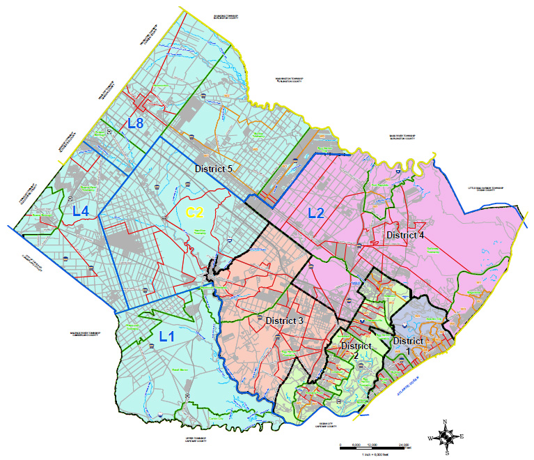
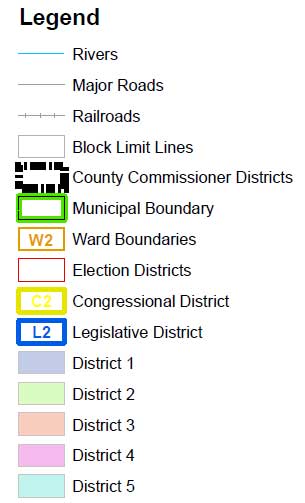
County Commissioner Districts
District 1
Atlantic City: All Wards
Longport Borough: All Election Districts
Margate City: All Election Districts
Ventnor City: All Election Districts
Egg Harbor Township: Election District 13
District 2
Absecon City: All Wards
Egg Harbor Township: Election District 1
Linwood City: All Wards
Northfield City: All Wards
Pleasantville City: All Wards
Somers Point City: All W ards
District 3
Egg Harbor Township: Election Districts 2-9, 11, 12, 17-22
Hamilton Township: Election Districts 4, 7-11 & 13
District 4
Brigantine City: All Wards
Galloway Township: All Election Districts
Egg Harbor Township: Election Districts 10 & 14-16
Port Republic City: All Wards
District 5
Mullica Township: All Wards
Egg Harbor City: All Wards
Hamilton Township: Election Districts 1, 2, 3, 5, 6 & 12
Hammonton Town: All Election Districts
Buena Borough: All Election Districts
Buena Vista Township: All Election Districts
Folsom Borough: All Election Districts
Weymouth Township: All Election Districts
Estell Manor City: All Election Districts
Corbin City: All Election Districts
General Notes and Data Sources:
This County Commissioner District map is for demonstration purposes only, any use of this product with respect to accuracy and precision shall be the sole responsibility of the end user.
The areas, boundaries and details, shown on this County Commissioner District map, are referenced, in part, from ground surveys, aerial l surveys and recorded plans, tax assessment maps and documents, and are to be used for County Commissioner District boundary purposes only.
This map was created, in part, utilizing parcel, municipal boundary and location data provided by the
Atlantic County Department of Regional Planning & Development.
Additional ward/election district boundary and location data was provided by the Atlantic County Board of County Commissioners. The 2020 Census demographic data was obtained and provided by the U.S . Census Bureau: http://www.census.gov/.
The 2020 election district/ward boundaries that may be portrayed on this map are a graphical approximation using revisions provided by the Atlantic County Board of County Commissioners working with their municipalities. These revisions are based on the 2020 census redistricting/rewarding process. Municipalities that the Atlantic County Board of elections did not revise election district/ward boundaries in 2020 are shown here using the 2010 election district/ward boundaries.
Additional GIS resource data and imagery data was provided by the New Jersey Geographic Information Network. The (NJ GIN) data was obtained and provided by the New Jersey Geographic Information Network (NJ GIN): https://njogis-newjersey.opendata.arcgis.com/. This secondary product has not been verified by (NJ GIN) and is not state-authorized.
Additional cadastral feature mapping data, such as, waterways, roadways, railroads, aerial orthophotography, etc. was obtained from the New Jersey Department of Environmental Protection (NJ DEP). The New Jersey Department of Environmental Protection (NJ DEP) data was obtained and provided by the New Jersey Department of Environmental Protection: http://www.state.nj.us/dep/gis/. This secondary product has not been verified by (NJ DEP) and is not state-authorized.
All positions are based on the following:
- NAD 83 (horizontal datum )
- New Jersey State Plane Coordinate System
- English units (feet)
The geodetic accuracy and precision of the Geographic Information System (GIS) data contained in this mapping has not been developed nor verified by a professional licensed land surveyor and shall not be nor is intended to be used in matters requiring delineation and location of true ground horizontal and/or vertical controls.
This map was prepared by Remington & Vernick Engineers and the County Commissioner district
boundary adjustments depicted were a dopted and a pproved by the Atlantic County Commissioner
Redistricting Commission 2022 on March 7, 2022, as per the Atl ntic County Board of County
Commissioners.
All County Commissioner/ward/election mapping was prepared in compliance with Title 19 and Title 40
statutes and is the property of the Atlantic County Board of County Commissioners and states the
following: “Not for distribution, no reproduction without permission by Atlantic County Board of County
Commissioners. For further information, please contact Atlantic County Board of County
Commissioners; (609) 645-5867.
General counsel was provided to the Atlantic County Board of County Commissioners during the
redistricting process by the following: James F. Ferguson, County Counsel; Randolph C. Lafferty, Esq.
Counsel for the Republican Party; Colin Bell, Esq. Counsel for the Democratic Party; and S cott
Salmon, Esq. Co-counsel for the Democratic Party.